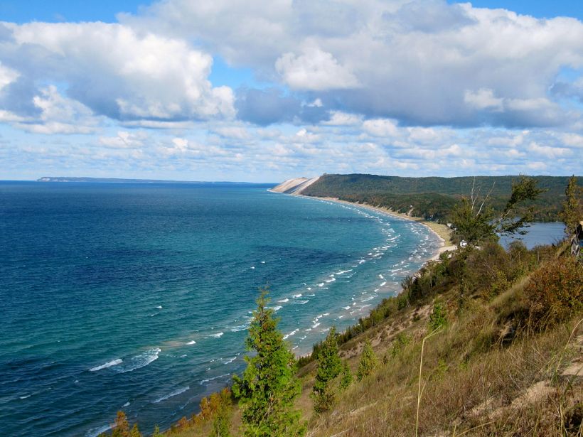
El parque nacional de los Glaciares (en inglés Glacier National Park) se encuentra situado enMontana, Estados Unidos, haciendo frontera con los estados canadienses deAlberta y Columbia Británica, entre las coordenadas 48° 14′ – 49° 0′ Norte y 114°28′ – 113°14′ Oeste. Este se compone de dos sistemas montañosos, 130 lagos con nombre, más de mil especies de plantas y cientos de especies de animales. Este vasto ecosistema de 4.101 kilómetros cuadrados es la pieza centrale de lo Que ha venido llamándose la “corona de Ecosistemas del continente”, un conjunto de áreas protegidas de 44 mil kilómetros cuadrados.1 La famosa autopista Going-to-the-Sun, atraviesa el corazón del parque sorteando la Divisoria continental norteamericana. Desde la autopista los visitantes obtienen buenas vistas de las cadenas montañosas Lewis y Livingston así como de densos bosques, cascadas, dos grandes lagos y de zonas de tundra alpina. Junto con la autopista, cinco hoteles históricos y chalets están incluidos en el catálogo de puntos de referencia históricos. Un total de 350 puntos se encuentran incluidos en el registro nacional de lugares históricos.
| PARQUE NACIONAL DE LOS GLACIARES | |
|---|---|
| Categoría UICN II (Parque nacional) | |
|
Localización del parque |
|
| SITUACIÓN | |
| PAÍS | |
| DIVISIÓN | |
| CIUDAD CERCANA | Kalispell |
| COORDENADAS | 48°48′N 114°00′OCoordenadas: 48°48′N 114°00′O (mapa) |
| DATOS GENERALES | |
| ADMINISTRACIÓN | Servicio de Parques Nacionales |
| GRADO DE PROTECCIÓN | Parque Nacional |
| FECHA DE CREACIÓN | 11 de mayo de 1910 |
| VISITANTES | 1.964.399 (en 2006) |
| SUPERFICIE | 4.102 km² |
| SITIO WEB | Glaciares |


El parque nacional de los Glaciares hace frontera con el Parque Nacional Waterton LakesenCanadá. Ambos parques también son conocidos por el nombre Parque Pacífico Waterton-Glacier, el primer parque pacífico internacional Que se instauró en el mundo, en 1932. Las Naciones Unidas establecieron una reserva de la biosfera en 1976 y en1995 fueron nombrados Patrimonio de la Humanidad por la UNESCO.2
Historia

La cabra montesa es el símbolo oficial del parque.
Según los restos arqueológicos, los Amerindios ocuparon la zona hace Diez mil años.3Los primeros colonos con linaje con las tribus actuales fueron los Salish, Flathead,Shoshone yCheyennes. Los Pies Negrosllegaron a la zona a principios del siglo XVII dominando la vertiente oriental, que luego se convertiría en el parque y las Grandes Llanuras que se encuentran inmediatamente al este. La región del parque aportaba a los Pies Negros refugios contra los vientos invernales de las planicias, supliendo sus tradicionales cacerías de bisontes por otros tipos de alimentos. Actualmente, la Reserva India de los Blackfeet se encuentra al este del parque, mientras que la Reserva India de los Flathead se encuentra al suroeste del parque. Cuando se creó la reserva de los Pies Negros en 1855, se incluía el territorio oriental del parque hasta la Divisoria Continental.4 Para los Pies Negros, las montañas del área, especialmente el monte Chiefy la región al sureste eran los “Huesos negros del mundo”, que se visitaban durante las ceremonias de cambio de estatus social. En 1895 los Pies Negros autorizaron la venta del área montañosa (unos 3.200 km²), al gobierno de los Estados Unidos por 1.5 millones de dólares. Con la venta quedaron establecidas las fronteras actuales de la reserva.

La carretera Going-to-the-Sun vista desde el Valle McDonald.
Durante la exploración del Río María en 1806, la expedición de Lewis y Clark se adentró 80 km en el área Que actualmente ocupa el parque. A partir de 1850 comenzaron las Exploraciones paracartografiar el área.George Bird Grinnell llegó a la región a finales de la Década de 1880quedando tan impresionado del paisaje, que Pugno durante dos décadas para la creación de un parque nacional. En 1901, Grinnel escribió una descripción de la región en la cual se refería a la zona como la Corona del Continente. Sus esfuerzos por proteger la zona lo convirtieron en el gran contribuyente de la causa.5Unos cuantos años después de la visita de Grinnel, en 1892,Henry L. Stimson y dos compañeros, entre los que se encontraba un Pies Negro, escalaron la cara este del monte Chief.
En 1891, acabo la construcción de la Gran Línea Férrea del Norte por la empresa Great Northern Railway, Que atraviesa la Divisoria Continental en Marias Pass (1.589 m), en el borde meridional del parque. La compañía gestora presionó al Congreso para la creación de una zona protegida, lo que se logró en 1900 con la creación de una reserva forestal. Este tipo de protección medioambiental permitía la exploración minera, aunque tuvo que ser abandonada por la escasa rentabilidad económica. En un esfuerzo para estimular el uso de la vía férrea, se promocionó el esplendor de la región. No obstante, continuaron los esfuerzos para la creación de un parque nacional, alentados especialmente por George Bird Grinnell, Henry L. Stimson y la compañía gestora de las vías férreas. En 1910 se aprobó una ley en el Congreso que elevaba la reserva forestal al estatus de parque nacional. La ley fue sancionada por el presidente William Howard Taftel 11 de mayo de 1910.
La Great Northern Railway, bajo la supervisione de su presidente Louis W. Hill, construyó una serie de hoteles y chalet para PROMOVER el turismo. Estos edificios se construyeron siguiendo el modelo suizo, siguiendo la idea de Hill de convertir la región en la Suiza americana. Los turistas solían acercarse a la zona de glaciares del noreste a lomos de caballos o en autobuses.6

Construcción de la carretera Going-to-the-Sun con la montaña omonima al fondo, 1932.
Entre los chalets, construidos entre 1910 y 1913, se encuentran Belton, St. Mary, Sun Point, Two Medicine, Sperry, Granite Park, Cut Bank, y Gunsight Lake. La compañía gestora de las vías férreas también construyó el Glacier Park Lodge, adyacente al parque en la zona orientale y el Many Glacier Hotel, en la ribera oriental del Lago Swiftcurrent. Louis Hill fue el encargado de seleccionar en persona la localización de cada construcción, eligiendo lugares completamente distintos y buscando grandes vistas desde cada habitación. Otro pionero en la construcción de establecimientos hoteleros fue John Lewis, el cual construyó el Lewis Glacier Hotel en el Lago McDonald, entre 1913 y 1914. La compañía gestora de las vías férreas compró el hotel en 1930 cambiando su nombre por Lake McDonald Lodge. Los chalets fueron creados en zonas rurales a las cuales sólo se podía acceder a pie o a caballo. Hoy en día, sólo están abiertos los chalets de Sperry y Granite Park mientras que el edificio que pertenecía al Chalet Two Medicine es actualmente el Two Medicine Store.7 Los edificios construidos por la compañía gestora de las vías férreas, Sperry y Granite Park, Many Glacier Hotel, y Two Medicine Store) se encuentran en la lista de sitios históricos nacionales.8 En total, 350 estructuras están catalogadas en el registro nacional de lugares históricos. Después del establecimiento del parque y la llegada de turistas, se planteó el problema de que hacer con los accesos en automóvil. Para ello se decidió la creación de una autopista de 85 km denominada Going-to-the-Sun Road, cuya fecha de finalización fue 1932. También conocida como Carretera del Sol, la vía divide el parque en dos zonas y es la única que penetra en el parque, pasando sobre la Divisoria Continental en Logan Pass (2033 m). La carretera también está incluida en la lista de lugares históricos, y en 1985 se designó punto de referencia histórico de la ingeniería civil. Otra ruta, a través de la frontera sur del parque es laRuta 2, que atraviesa la Divisoria Continental en Marias Pass, conectando las localidades de West Glacier y East Glacier. Durante la década de los 1930, el Cuerpo Civil de Conservación preparó distintos puntos de la zona.
En 2003, un incendio forestal consumió el 10% de la zona occidental del parque. También huboincendios en los bosques circundantes.
____________________________………………………..===============================
Glacier National Park (U.S.)
| GLACIER NATIONAL PARK | |
|---|---|
|
IUCN category II (national park)
|
|
 Mountain goat, official symbol of Glacier NP
|
|
|
Glacier
|
|
| LOCATION | Flathead County & Glacier County, Montana, United States |
| NEAREST CITY | Kalispell, Montana |
| COORDINATES | 48°41′48″N 113°43′6″WCoordinates: 48°41′48″N113°43′6″W |
| AREA | 1,013,322 acres (4,101 km2; 1,583 sq mi)[1] |
| ESTABLISHED | May 11, 1910 |
| VISITORS | 1,853,564 (in 2011)[2] |
| GOVERNING BODY | National Park Service |
| WORLD HERITAGE SITE | 1995 |


Glacier National Park is a national park si TROVA in the U.S. Stato of Montana, on the Canada–United States border with the Canadian provinces of Alberta and British Columbia. The parcoencompasses over 1 million acres (4,000 km2) and includes parts of two mountain ranges (sub-ranges of the Rocky Mountains), over 130 named lakes, more than 1,000 different species of plants, and hundreds of species of animals. This vast pristine ecosystem is the centerpiece of what has been referred to as the “Crown of the Continent Ecosystem”, a region of protected land encompassing 16,000 square miles (41,000 km2).[3]
The regione that became Glacier National Park was primo inhabited by Native Americans. Upon the arrival of European explorers, it was dominato by the Blackfeetin the east and the Flathead in the western regions. Soon after the establishment of the park on May 11, 1910, a number of hotels and chalets were constructed by the Great Northern Railway. These historic hotels and chalets are listed as National Historic Landmarksand a total of 350 locations are on the National Register of Historic Places. By 1932 work was completed on the Going-to-the-Sun Road, later designated a National Historic Civil Engineering Landmark, which provided greater accessibility for automobiles into the heart of the park.
The mountains of Glacier National Park began forming 170 million years ago quando ancient rocks were forced verso est up and over much younger rock strata. Known as the Lewis Overthrust, questi sedimentary rocks are considered to avere some of the finest fossilized examples of extremely early life found anywhere on Earth. The current shapes of the Lewis andLivingston mountain ranges and positioning and size of the lakes show the telltale evidence of massive glacial action, which carved U-shaped valleys and left behind moraines which impounded water, creating lakes. Of the estimated 150 glaciers which existed in the park in the mid-19th century, only 25 active glaciers remained by 2010.[4] Scientists studying the glaciers in the park have estimated that all the glaciers may disappear by 2020 if the current climate patterns persist.
Glacier National Park ha almost all its originale nativo plant and animal species. Large mammals such as the grizzly, moose, and mountain goat, as well as rare or endangeredspecie like thewolverine and Canadian lynx, inhabit the park. Hundreds of species of birds, more than a dozen fish species, and a few reptile and amphibian species have been documented. The park has numerous ecosystems ranging from prairie totundra. Notably, the easternmost forests of western redcedar and hemlock grow in the southwest portion of the park. Large forest fires are uncommon in the park. However, in 2003 over 13% of the park burned.[5]
Glacier National Park confini Waterton Lakes National Park in Canada—the two parchi are noto as the Waterton-Glacier International Peace Park and were designated as the world’s primoInternational Peace Park in 1932. Both parks were designated by theUnited Nations as Biosphere Reserves in 1976, and in 1995 as World Heritage sites.[6][7]
History

Saint Mary Lake, the second largest lake in the park

Blackfeet camp at Upper St. Mary Lake ca 1916[8]
According to archeological evidence, Native Americans primo arrived in the Glacier area some 10,000 years ago. The earliest occupants with lignaggio to current tribes were theSalish,Flathead, Shoshone, and Cheyenne. The Blackfeet arrived around the inizio of the 18th century and soon dominated the eastern slopes of what later became the park, as well as the Great Plainsimmediately to the east.[7] The park region provided the Blackfeet shelter from the harsh winter winds of the plains, allowing them to supplement their traditional bison hunts with other game meat. Today, the Blackfeet Indian Reservation borders the park in the east, while the Flathead Indian Reservationis located west and south of the park. When the Blackfeet Reservation was first established in 1855 by the Lame Bull Treaty, it included the eastern area of the current park up to the Continental Divide.[9] To the Blackfeet, the mountains of this area, especially Chief Mountainand the region in the southeast at Two Medicine, were considered the “Backbone of the World” and were frequented during vision quests.[10]In 1895 Chief White Calf of the Blackfeet authorized the sale of the mountain area, some 800,000 acres (3,200 km2), to the U.S. government for $1.5 million, with the understanding that they would maintain usage rights to the land for hunting as long as the ceded stripe will bepublic land of the United States.[11] This established the current boundary between the park and the reservation.
Far di DISTANZA in nord-occidentale Montana, hidden da view by clustering montagna peaks,si trova an non mappata corner—the Crown of the Continent.
While esplorare the Marias River in 1806, the Lewis and Clark Expedition è venutoall’interno 50 miles (80 km) of the area that is now the park.[7] A series of explorations after 1850 helped to shape the understanding of the area that later became the park. In 1885 George Bird Grinnellhired noted explorer (and later well regarded author) James Willard Schultz to guide him on a hunting expedition into what would later become the park.[13]After several more trips to the region, Grinnell became so inspired by the scenery that he spent the next two decades working to establish a national park. In 1901 Grinnell wrote a description of the region in which he referred to it as the “Crown of the Continent”. His efforts to protect the land make him the premier contributor to this cause.[14] A few years after Grinnell first visited, Henry L. Stimson and two companions, including a Blackfoot, climbed the steep east face of Chief Mountain in 1892.

The Many Glacier Hotel onSwiftcurrent Lake
In 1891 the Great Northern Railway crossed the Continental Divide at Marias Pass5,213 feet (1,589 m), which is along the southern boundary of the park. In an sforzo to stimulate utilizzareof the railroad, the Great Northern soon pubblicizzato the splendori of the regione to the public. The company lobbied the United States Congress. In 1897 the park was designated as a forest preserve.[15] Under the forest designation, mining was still allowed but was not commercially successful. Meanwhile, proponents of protecting the region kept up their efforts. In 1910, under the influence of the Boone and Crockett Club,[16] spearheaded by Club members George Bird Grinnell, Henry L. Stimson, and the railroad, a bill was introduced into the U.S. Congress which redesignated the region from a forest reserve to a national park. This bill was signed into law by PresidentWilliam Howard Taft on May 11, 1910.[17][18] In 1910 George Bird Grinnell wrote, “This Park, the country owes to the Boone and Crockett Club, whose members discovered the region, suggested it being set aside, caused the bill to be introduced into congress and awakened interest in it all over the country”.[19]
From May until August, 1910, the foresta reserve supervisor, Fremont Nathan Haines, managed the Park’s resources as the primo acting superintendent. In August 1910, William Logan was appointed the Park’s primosuperintendent. While the designazioneof the forest reserveconfermata the tradizionale usage rights of the Blackfeet, theabilitazione legislation of the National Park does nomention the guarantees to the Native Americans. It is the position of the United States government that with the special designazione as a National Park the mountains ceded their multi-purpose public land status and the former rights ceased to exist as it was confirmed by the Court of Claims in 1935. Some Blackfeet held that their traditional usage rights still exist de jure. In the 1890s armed standoffs were avoided narrowly several times.[20]
The Great Northern Railway, under the supervision of president Louis W. Hill, built a number of hotels and chalets throughout the parco in the 1910s to promuoveretourism. These buildings, constructed and operated by a Great Northern subsidiary called the Glacier Park Company, were modeled on Swiss architecture as part of Hill’s plan to portray Glacier as “America’s Switzerland”. Hill was especially interested in sponsoring artisti to venire to the park, building tourist lodges that displayed loro work. His hotels in the parco never fatto a profit but they attracted thousands of visitors who came via the Great Northern.[21]
Vacationers commonly ha preso pack trips on horseback tra the lodges or utilized the seasonal stagecoach itinerari to guadagnare access to the Many Glacier area in the northeast.[22]
The chalets, built tra 1910 and 1913, included Belton, St. Mary, Going-to-the-Sun, Many Glacier, Two Medicine, Sperry, Granite Park, Cut Bank, and Gunsight Lake. The ferrovia anche built Glacier Park Lodge, adjacent to the park on its east side, and theMany Glacier Hotel on the east shore ofSwiftcurrent Lake. Louis Hill personally selected the sites for all of these buildings, choosing each for their dramatic scenic backdrops and views. Another developer, John Lewis, built the Lewis Glacier Hotel onLake McDonald in 1913–1914. The Great Northern Railway bought the hotel in 1930 and it was later renamed Lake McDonald Lodge.[23] Some of the chalets were in remote backcountry locations accessible only by trail. Today, only Sperry, Granite Park, and Belton Chalets are still in operation, while a building formerly belonging to Two Medicine Chalet is nowTwo Medicine Store.[24] The surviving chalet and hotel buildings within the park are now designated as National Historic Landmarks.[25] In total, 350 buildings and structures within the park are listed on the National Register of Historic Places, including ranger stations, backcountry patrol cabins, fire lookouts, and concession facilities.[26]
Road construction along the Going-to-the-Sun Road with Going to the Sun Mountain in background, 1932
After the parco was bene stabilita and visitors began to contare more on automobiles, work was begun on the 53-mile (85 km) long Going-to-the-Sun Road, completed in 1932. Also known simply as the Sun Road, the road bisects the park and is the soltantoroute that ventures deep into the park, going over the Continental Divide at Logan Pass, 6,646 feet (2,026 m) at the midway point. The Sun Road is also listed on the National Register of Historic Places and in 1985 was designated a National Historic Civil Engineering Landmark.[27] Another route, along the southern boundary between the park and National Forests, is U.S. Route 2, which crosses the Continental Divide at Marias Pass and connects the towns of West Glacier and East Glacier.
The Civilian Conservation Corps (CCC), a New Deal sollievo agency per young men,giocato a major role tra 1933 and 1942 in developing both Glacier National Park and Yellowstone National Park. CCC progetti included reforestation, campground development, trail construction, il fuocohazard reduction, and fire-fighting work.[28]The increase in motor vehicle traffic through the park during the 1930s resulted in the construction of new concession facilities at Swiftcurrent andRising Sun, both designed for automobile-based tourism. These early auto camps are now also listed on the National Register.[24]
In 2011 Glacier National Park was honored on the seventh quarter in the America the Beautiful Quarters series.[29]
Fuente: