| IZTAPALAPA | ||
|---|---|---|
| Delegación de México | ||
|
||
 Localización de Iztapalapa en el Distrito Federal (México) |
||
| COORDENADAS: | 19°21′30″N99°05′35″OCoordenadas: 19°21′30″N99°05′35″O (mapa) | |
| ENTIDAD | Delegación | |
| • PAÍS | ||
| • ENTIDAD FEDERATIVA | Distrito Federal | |
| • COORDINACIONES TERRITORIALES |
1. Aculco 2. Centro 3. Ermita-Zaragoza 4. San Lorenzo Tezonco 5. Paraje San Juan 6. Sierra de Santa Catarina |
|
| JEFE DELEGACIONAL | Jesús Salvador Valencia Guzmán |
|
| FUNDACIÓN CREACIÓN DE LAS DELEGACIONES DEL DF |
Época prehispánica | |
| SUPERFICIE | Puesto 4.º | |
| • TOTAL | 116,13 km² | |
| ALTITUD | ||
| • MEDIA | 2240 msnm | |
| • MÁXIMA | Guadalupe, 2820 msnm | |
| • MÍNIMA | Valle de México, 2240 msnm | |
| POBLACIÓN (2010) | Puesto 1.º | |
| • TOTAL | 1 815 786 hab. | |
| • DENSIDAD | 15,635.80 hab/km² | |
| • POBL. URBANA | 1 815 786 hab. | |
| GENTILICIO | Iztapalapense | |
| CÓDIGO POSTAL | 09000-09999 | |
| CLAVE LADA | (55) | |
| INEGI | 09007 | |
| [Editar datos en Wikidata] | ||


Iztapalapa es una de las 16 delegaciones del Distrito Federal mexicano. Posee una superficie algo mayor a 116 km2 y se localiza en el oriente de la capital mexicana, ocupando la porción sur del vaso del lago de Texcoco. En el censo de población y vivienda realizado por el INEGI en el año 2010 registro una población de 1 815 786 habitantes,1 con esto es la demarcación más poblada de todo el país.
El nombre de esta delegación se debe a la antigua ciudad de Iztapallapan, fundada por losculhuas entre la falda norte del cerro de la Estrella y la ribera del lago de Texcoco. La evidencia más antigua que se conoce de la presencia humana en Iztapalapa es el llamado Hombre de Aztahuacán, al que se le atribuye una antigüedad de 9000 años. A lo largo de la historia precolombina, el territorio iztapalapense conoció el desarrollo de diversas comunidades sedentarias dedicadas a la agricultura. Durante el período Clásico mesoamericano (ss. III-VII d. C.), se estableció un pueblo de cultura teotihuacana en el norte del cerro de la Estrella.Culhuacán, población fundada en el siglo VII, recibió una parte de la diáspora que inició con el declive deTeotihuacan. Durante los siguientes siglos, Culhuacán fue uno de los más importantes altépetl en el valle de México, tuvo un papel muy destacado en el desarrollo de la cultura tolteca y su casa gobernante dio aMéxico-Tenochtitlan su primer tlatoani. En la época de la Conquista, Iztapallapan era gobernada por Cuitláhuac, hermano de Moctezuma Xocoyotzin. A la muerte de éste, Cuitláhuac asumió el mando de los mexicas y logró derrotar a los españoles en la Noche Triste. Después de la derrota de México-Tenochtitlan, la antigua Iztapalapa fue destruida. Con la independencia de México, Iztapalapa vino a ser una de las municipalidades del estado de México hasta la creación del Distrito Federal en 1824.

En comparación con el resto del Distrito Federal, Iztapalapa presenta indicadores socioeconómicos menos favorables. Si bien alberga a la quinta parte de los capitalinos, su participación en la economía es mucho menor. El sector de los servicios constituye el componente más importante de su PIB, y un número importante de sus habitantes deben trasladarse fuera de la demarcación para conseguir trabajo. La infraestructura y los servicios urbanos se encuentran menos desarrollados o son deficientes, particularmente en el caso de la distribución del agua potable, uno de los retos más importantes para los gobiernos locales. En términos generales, la delegación posee un desarrollo humano alto, pero hay muchos contrastes en su interior. La marginación de los vecindarios en la zona poniente es mucho menor en comparación con las colonias populares de la sierra de Santa Catarina.
Como otras demarcaciones periféricas de la capital mexicana, Iztapalapa recibió las olas inmigratorias provenientes del resto del país, incluyendo el centro de la Ciudad de México. Esta situación se acentuó en la década de 1960 con el auge económico del país y en la década de 1980 después del terremoto de 1985. Los recién llegados se establecieron en tierras que se habían dedicado al cultivo hasta entonces, incluyendo laschinampas de sus pueblos originarios. En los nuevos barrios populares ocurrió un importante fenómeno de organización civil, muy notable en el caso de las colonias de la sierra de Santa Catarina y el sur de San Lorenzo Tezonco.
Toponimia

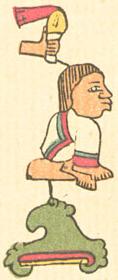
Glifo Iztapallapan
El nombre de la delegación se debe a su cabecera. Iztapalapa es un topónimo de origennáhuatl. Deriva de las palabras iztapal-li ‘adoquín, piedra labrada’, ā-tl ‘agua’, y -pa(n)‘sobre’. Por lo tanto, se traduce como ‘Adoquinado sobre el agua’. Montemayor y colaboradores opinan que el topónimo se puede traducir como ‘Lugar donde las aguas se atraviesan’, a partir de los vocablosixtlápal ‘atravesado’, ā-tl ‘agua’ y -pan ‘locativo’.2Esto se debe a que esta demarcación junto con otros espacios aledaños, tuvo sus asentamientos en parte firme y en agua mediante chinampas.3
El emblema de la delegación Iztapalapa es el glifo que aparece en algunos manuscritos de los primeros años después de la conquista de México, elaborados por indígenas nahuas. Este glifo y sus variaciones representan una piedra rodeada por agua. En algunas versiones la losa se convierte en el glifo nahua tépetl, cuya punta está curvada hacia abajo y del cual mana agua. Durante la segunda mitad de la década de 1980, el emblema del gobierno delegacional fue sustituido por la imagen de Cuitláhuac, antiguo señor de Iztapallapan que dirigió a los mexicas en su enfrentamiento contra los españoles el 30 de junio de 1520 y luego fue investido como tlatoani de México-Tenochtitlan. A partir de 1988, nuevamente se empleó el glifo Itztapallapan.
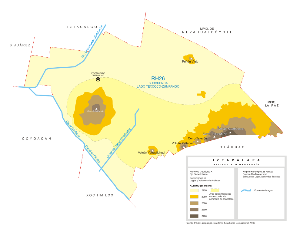
Hidrografía

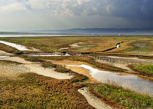
Vista del canal Nacional a la altura del puente del Toro en San Andrés Tomatlán. Es el último vestigio visible del ambiente lacustre de Iztapalapa.
Iztapalapa se encuentra completamente dentro de la región hidrológica del río Pánuco. Forma parte de la subcuenca de Texcoco–Zumpango, que fue unida artificialmente en el siglo XVII a la cuenca del río Moctezuma a través de un canal que tenía como propósito desaguar el valle de Anáhuac en el río Tula, para evitar las frecuentes inundaciones que afectaban a la Ciudad de México. Las obras del desagüe de los lagos han continuado desde la época colonial hasta la actualidad, sin alcanzar el propósito de poner fin a las inundaciones en la megalópolis del valle de México.16
La mitad norte de Iztapalapa corresponde a lo que fue el sur del lago de Texcoco. Es una planicie completamente seca, de una gran salinidad. Al sur de la península de Iztapalapa se encontraba ellago de Xochimilco, del que sólo se conservan algunos canales entre laschinampas de los pueblos xochimilquenses y tlahuaquenses, así como los canales de Chalco y Nacional que constituyen el límite sudoccidental de Iztapalapa.17 Como otros pueblos de la ribera de los lagos, los iztapalapenses también contaban con chinampería, pero estas zonas se perdieron cuando elcanal de La Viga fue cegado y el río Churubuscose entubó para construir sobre su cauce elCircuito Interior.
Climas
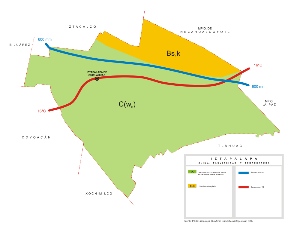
Según la Carta de Climas del Inegi, el 82.42% de Iztapalapa posee clima templado subhúmedo, con lluvias en verano. El resto del territorio presenta un clima semiseco templado.18 La temperatura anual promedio (calculada con base en una observación de 30 años) es de 16.6 °C,19siendo más cálida en el mes de junio, cuando alcanza los 19 °C, y la más baja en enero, con 13.1 °C.20 La precipitación anual promedio es de 616.8 mm, con una mayor pluviosidad durante los meses del verano.21
Iztapalapa
| IZTAPALAPA | ||
|---|---|---|
| Delegación | ||
 View of Iztapalapa |
||
|
||
 Iztapalapa within the Federal District |
||
| COUNTRY | Mexico | |
| FEDERAL ENTITY | D.F. | |
| ESTABLISHED | 1928 | |
| NAMED FOR | Ancient Aztec neighborhood | |
| SEAT | Aldama No. 63 esq. Ayuntamiento, Barrio San Lucas. CP. 09000. | |
| GOVERNMENT | ||
| • JEFE DELEGACIONAL | Jesús Valencia (PRD) | |
| AREA | ||
| • TOTAL | 117 km2 (45 sq mi) | |
| POPULATION AS OF 2010 | ||
| • TOTAL | 1,815,768 | |
| • DENSITY | 16,000/km2 (40,000/sq mi) | |
| TIME ZONE | Central Standard Time (UTC-6) | |
| • SUMMER (DST) | Central Daylight Time (UTC-5) | |
| POSTAL CODES | 09000 – 09990 | |
| AREA CODE(S) | 55 | |
| WEBSITE | http://www.iztapalapa.gob.mx | |

Iztapalapa is one of the Federal District of Mexico City’s 16 boroughs, located on the east side of the entity. The borough is named after and centered on the formerly independent municipality of Iztapalapa, which is officially called Iztapalapa de Cuitláhuac for disambiguation purposes. The rest is made up of a number of other communities which are governed by the city of Iztapalapa.
With a population of 1.8 million as of 2010, Iztapalapa is the most populous borough of Mexico City, and it is also the most populous municipality in the country. Over 90% of its territory is urbanized. The borough transitioned from a rural area with some farms and canals as late as the 1970s, to an area with the only green areas in parks and almost all of its people employed in commerce, services and industry. This is the result of a large influx of people into the borough starting from the 1970s and which still continues. The area has a high level of socioeconomic marginalization, with a significant number of people lacking sufficient access to clean potable water. Crime is also a major problem, with much of it related to drug trafficking and poverty. However, the borough is home of one of Mexico City’s major cultural events, the annual Passion Play in which 450 borough residents participate and about 2 million attend as spectators.
The borough and city
Iztapalapa today is a borough of the Federal District of Mexico City, centered on what used to be an independent settlement with its origins in the pre-Hispanic period. It has a territory of 116.67km2 (11,506 hectares), and is located on the east side of the Federal District bordering the boroughs of Iztacalco, Xochimilco, Tláhuac, Coyoacán andBenito Juárez. The State of Mexicoborders the borough on the east side, and Iztapalapa has strong cultural and economic ties to this part of the state.[1][2]
The borough was created in 1928, centered on and named after a formerly independent municipality within the Federal District, which already had governing authority over a number of surrounding communities.[3]The modern borough is made up of 15 “barrios” or neighborhoods, considered to be part of city of Iztapalapa, and 18 other “pueblos” or communities outside of it.[4]To distinguish the original city of Iztapalapa from the rest of the borough, it was officially named Iztapalapa de Cuitláhuac in 2006 in honor of thetenth Aztec emperor.[4] However, eight of the barrios are considered to be the historic center of the city of Iztapalapa, which are La Asunción, San Ignacio, Santa Barbara, San Lucas, San Pablo, San Miguel, San Pedro and San José. Records of the “eight barrios of Iztapalapa” go back at least until 1898.[3][5] Borough authorities have sought “Barrios Mágicos Turísticos” (Magical Tourism Neighborhoods) status for these, for a program similar to the “Pueblos Mágicos” tourism program run by the federal government. The goal is to attract visitors to these neighborhoods as well as other landmarks of the borough such as theCerro de la Estrella, Pueblo Culhuacán, the Churubusco Gardens, La Magdalena Atlazolpa, Los Reyes, San Antonio Culhuacán, Mexicalzingo, the San Lorenzo Cemetery, San Andrés Tetepilco and San José Aculco.[6]
Elevation and climate

Yohualiuhqui volcano, as seen from the San Lorenzo Tezonco cemetery
The borough has an average elevation of 2240 masl and extends over firm land and what was former lake bed of Lake Texcoco.[7][8] Some of the firm land is alluvial plainbut most of it are elevations such as the Cerro de la Estrella (2,460 masl), Peñón Viejoor Peñon del Marqués(2,400 masl), and the Sierra de Santa Catalina, which contains theCerro Tecuatzi (2,640 masl), Cerro Tetecón (2,480 masl), and the Guadalupe Borrego(2,820 masl), Xaltepec(2,500 masl); andYuhualixqui (2,420 masl) volcanoes.[1][8]These are recent geological formations, with evidence of lava flow still existent and none extend over 1000 meters above the valley floor. Culturally, the most important of these elevations is the Cerro de la Estrella, which was the site of the New Fire ceremony.[8]Since the pre-Hispanic period, Lake Texcoco has been drained, leaving behind only two natural river called the Churubusco and La Piedad, which unite to form the Unido River, and a few canals. However, the rivers are encased in tubes as is one of the canals, and most of theCanal Nacional which forms part of the border of the borough has been filled into to createCalzada La Viga road. For this reason, there are no longer any naturally occurring surface water.[9]
The climate of the area is divided into four zones. One consists of a warm wet climate with temperatures above 18C in the coldest months. Another is a temperate wet climate with temperatures between -3 and 18C in the coldest months. One has a relatively dry climate with various temperatures, and the last consists of a cold climate with average temperature not exceeding 6.5C. Most of the area falls into the temperate category and all receive most of their rainfall in the summer and early fall.[10]
Fuente:


.jpg)


.jpg)

.jpg)


.svg)


